


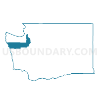
Voting District 600, Jefferson County, Washington
About
Outline

Summary
| Unique Area Identifier | 684533 |
| Name | Voting District 600 |
| County | Jefferson County |
| State | Washington |
| Area (square miles) | 838.29 |
| Land Area (square miles) | 805.68 |
| Water Area (square miles) | 32.62 |
| % of Land Area | 96.11 |
| % of Water Area | 3.89 |
| Latitude of the Internal Point | 47.82354880 |
| Longtitude of the Internal Point | -123.81400070 |
Maps


Graphs
Select a template below for downloading or customizing gragh for Voting District 600, Jefferson County, Washington


Neighbors
Neighoring Voting District (by Name) Neighboring Voting District on the Map
- Voting District 201, Jefferson County, WA
- Voting District 204, Jefferson County, WA
- Voting District 601, Jefferson County, WA
- Black Diamond Voting District, Clallam County, WA
- Blyn Voting District, Clallam County, WA
- Bogachiel Voting District, Clallam County, WA
- Elwha Voting District, Clallam County, WA
- Mount Angeles Voting District, Clallam County, WA
- Piedmont Voting District, Clallam County, WA
- Quileute Voting District, Clallam County, WA
- Riverside Voting District, Clallam County, WA
- Sappho Voting District, Clallam County, WA
- Sun Voting District, Clallam County, WA
- Water: Pacific Ocean, Jefferson County, WA
Top 10 Neighboring County Subdivision (by Population) Neighboring County Subdivision on the Map
- Port Angeles CCD, Clallam County, WA (29,410)
- Sequim CCD, Clallam County, WA (18,401)
- Agnew-Carlsborg CCD, Clallam County, WA (10,573)
- Forks CCD, Clallam County, WA (6,453)
- Crescent CCD, Clallam County, WA (3,370)
- Quilcene Bay-Brinnon CCD, Jefferson County, WA (3,066)
- West End CCD, Jefferson County, WA (881)
Top 10 Neighboring Unified School District (by Population) Neighboring Unified School District on the Map
- Port Angeles School District, WA (30,152)
- Sequim School District, WA (29,342)
- Quillayute Valley School District, WA (6,709)
- Crescent School District, WA (2,609)
- Quilcene School District, WA (1,760)
- Brinnon School District, WA (1,250)
- Queets-Clearwater School District, WA (629)
Top 10 Neighboring State Legislative District Lower Chamber (by Population) Neighboring State Legislative District Lower Chamber on the Map
Top 10 Neighboring State Legislative District Upper Chamber (by Population) Neighboring State Legislative District Upper Chamber on the Map
Top 10 Neighboring 111th Congressional District (by Population) Neighboring 111th Congressional District on the Map
Top 10 Neighboring Census Tract (by Population) Neighboring Census Tract on the Map
- Census Tract 23, Clallam County, WA (3,983)
- Census Tract 6, Clallam County, WA (3,370)
- Census Tract 18, Clallam County, WA (2,739)
- Census Tract 9507.02, Jefferson County, WA (2,131)
- Census Tract 15, Clallam County, WA (2,072)
- Census Tract 9502.02, Jefferson County, WA (1,816)
- Census Tract 4, Clallam County, WA (1,758)
- Census Tract 9901, Clallam County, WA (0)
- Census Tract 9900, Jefferson County, WA (0)
Top 10 Neighboring 5-Digit ZIP Code Tabulation Area (by Population) Neighboring 5-Digit ZIP Code Tabulation Area on the Map
- 98382, WA (26,856)
- 98362, WA (22,230)
- 98363, WA (13,343)
- 98331, WA (6,261)
- 98376, WA (1,998)
- 98320, WA (1,250)